
Mountains Of The Moon - Summit The Rwenzoris

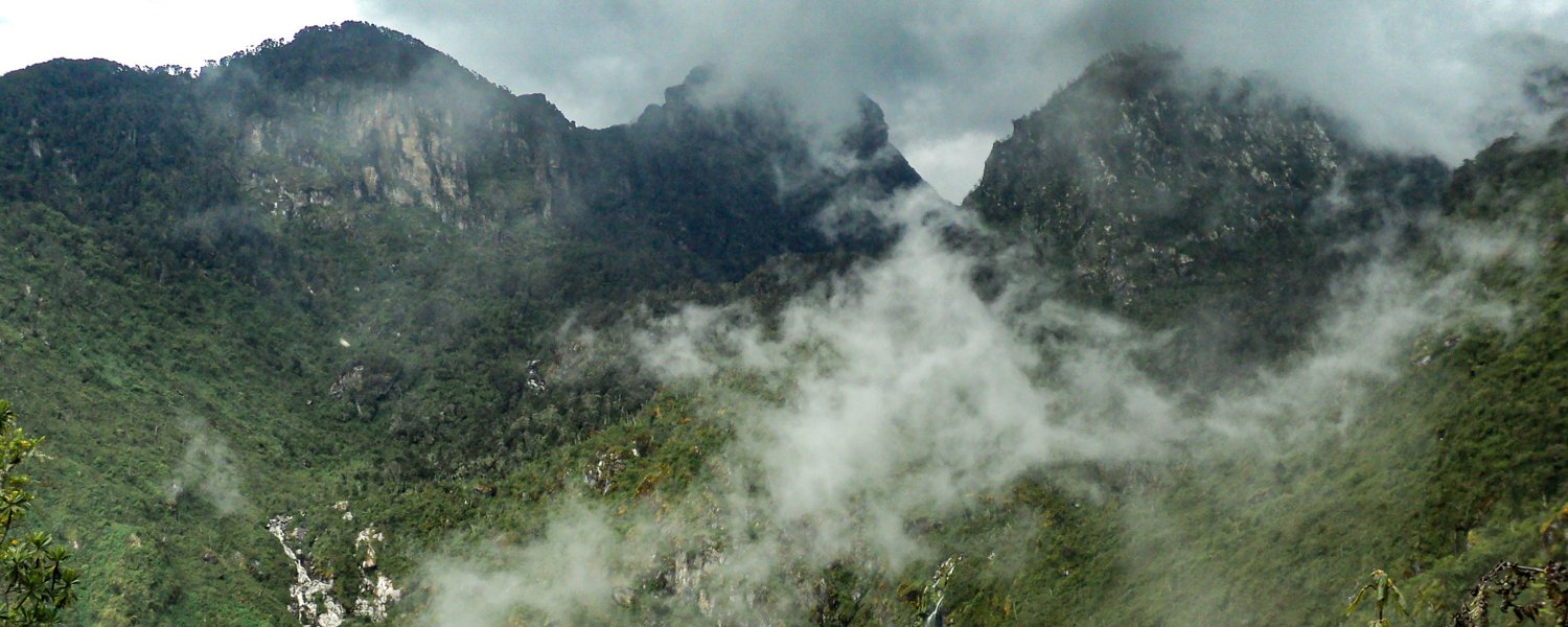
Venture into the stunning ‘Mountains of the Moon’ or Rwenzori Mountains to trek to the equatorial snow capped Margherita Peak on Mount Stanley. This is Africa’s third highest peak which rises up from the savannah plains from the south west, Lake Albert to the north east and vast expanse of congolese rainforest to the west. This hiking adventure requires a good level of fitness, but your expert and experienced guides will be joining to assist you as you explore this otherworldly montane environment.
Itinerary - Mountains Of The Moon [TACP8-001]
Day One
Transfer & Crater Lakes Drive
Transfer from Entebbe to the Ndali-Kasenda Crater Lakes. Estimated journey time: 8 hrs.
[scheduled flight option available]
Discover the Ndali–Kasenda crater-lakes from the comfort of your safari vehicle, accompanied by an expert local guide. These lakes were created during the volcanic upheaval of the Great Rift Valley and consist of many stunning pools dotting the landscape. On your scenic drive you will be meandering through a rural landscape of rolling hills and farmland and be able to view four of the lakes found here, including Lake Nyinambuga, Lake Kifuruka, Lake Lyantonde and Lake Rukwanzi. Your guide will be on hand to explain the history of the area, and give you further insights into the local traditions and village life as you enjoy exploring one of the most scenic vistas anywhere in Uganda.
Estimated excursion time: 1.5 - 2 hrs
Transfer from Ndali-Kasenda to Kilembe. Estimated journey time: 3 hrs
Day Two
Kilembe to Sine Hut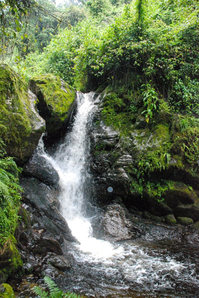
Starting Point: 1450 metres
End Point: 2560 metres
Highest Point: 2560 metres
Time Estimate: 5 – 8 hours
Distance: 9.2 km
Your adventure into the ‘Mountains of the Moon’ begins by walking 2.2km to the Uganda Wildlife Authority ranger post at 1,727m on the park boundary. This should take about one hour to complete, where on arrival you will receive a briefing from the rangers on the rules of the national park. You will then enter the park and follow a trail along the rift valley floor, passing through the tall trees of the afro-montane forest zone. It’s a steady climb with a multitude of birds to spot, blue monkeys and the chance to hear chimpanzee calls echo across the valley. At times, visitors can also see troupes of 15 to 20 colobus monkeys racing through the treetops, as well as the chance of sighting the L’hoest monkey, which is part of the Bakonzo tribe’s cultural emblem and are, protected by the virtue of the Omusinga (king). Additionally there is a wide variety of plant species to identify; from forest trees to bamboo thickets, low shrubs, flowers, fungi, and with many moss and lichen covered vines hanging from the tall trees, creating an amazing appeal. Enoch Falls are just 200m from Sine Hut and well worth the short stroll after your long day trekking to experience the white water as it streams down the mountain side.
Day Three
Sine Hut to Mutinda Rock Shelter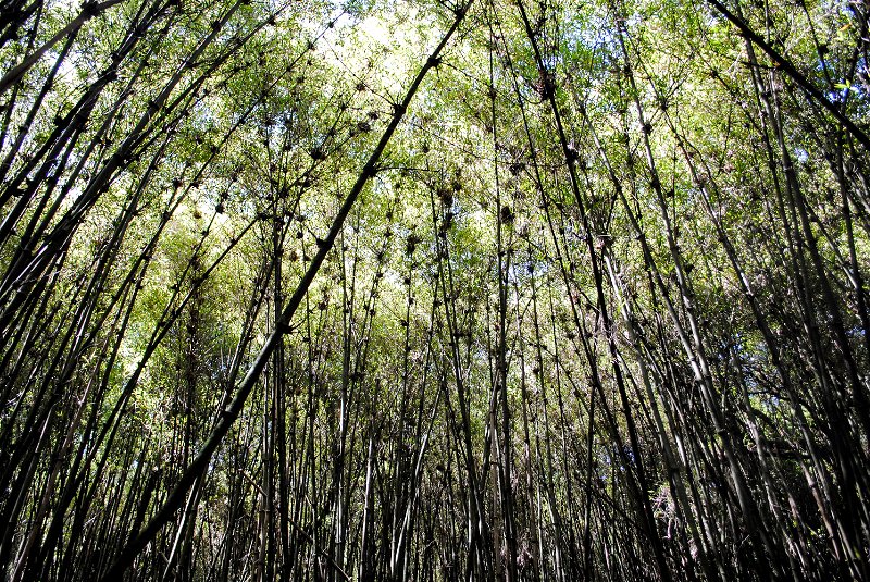
Starting Point: 2560 metres
End Point: 3588 metres
Highest Point: 3925 metres
Time Estimate: 6 – 8 hours
Distance: 7 km
After a hearty breakfast, your day of trekking begins at 8.30am and you’ll soon enter the bamboo-mimulopsis zone. It will be a steep climb with many high steps. In the wet season the bamboo area is rather muddy making the going slow. However the atmosphere and the forest is beautiful as you climb 551m in altitude and a distance of 1.8km to Kalalama Camp at 3,147m. Here you’ll reach the heather-rapanea zone where you can take a rest and a quick cup of tea or coffee before continuing. The trail then meanders up and over several small knolls along a ridgetop then drops down the side of the valley before climbing again. In doing so you’ll cross several small streams and pass close to moss covered waterfalls. You’ll climb steadily alongside a beautiful mossy river, which tumbles down over the rocks where giant heather trees, whose trunks are covered in green moss with old man beard hanging from the branches overhead. The trail twists and turns as you climb up the deep valley, which has an enormous variety of plants and flowers. This valley is unique with an abundance of giant heather trees creating a beautiful atmosphere, often shrouded in mist. Once you reach Mutinda Rock Shelter, which is set near a small and waterfall and offers a chance to wash, refresh and relax, you may wish to climb up to the top of the Mutinda lookout (one and a half hours up and one hour down). The view and the atmosphere is amazing as you stand on moss covered rocks at 3,925m with views across the Rwenzori mountains and down to Kasese town and Lake George on a clear day.
Day Four
Mutinda Rock Shelter to Bugata Camp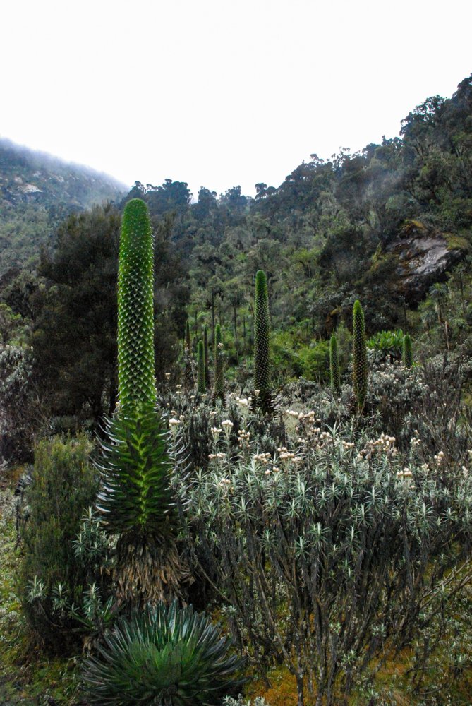
Starting Point: 3588 metres
End Point: 4100 metres
Highest Point: 4100 metres
Time Estimate: 4 – 6 hours
Distance: 4.9km
As you pass through the alpine zone today the trail is boggy particularly in the wet season, but you can step from tussock to tussock to make the going a little easier. You will cross Mutinda Valley through the tussock grass and everlasting flowers, interspersed with giant lobelia. Then climb a steep route to the wide and undulating Namusangi Valley at 3,840m. Follow the trail up the valley crossing many bogs as you go until you reach the valley head, which ends abruptly with sheer waterfalls and fantastic views of Mutinda Peak. In the dryer season you may choose not to walk directly up the valley but along a more scenic trail, which meanders along the hilltops with fantastic views of Lake Nusuranja from Plozza Rock. From Plozza Rock you also get fantastic views down the valley across nine lakes, ringed by rugged peaks and ridges. Your destination today is Bugata Camp which is situated on the Bamwanjara Pass high above Bugata Lake with views across Lake Kopello to Weismann’s Peak, which is often covered with snow. Down the valley you’ll get views of Lakes Africa and Kanganyika and the many small peaks towards Mutinda Camp.
Day Five
Bugata Camp to Hunwick Camp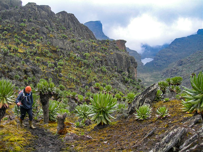
Starting Point: 4100 metres
End Point: 3,874 metres
Highest Point: 4450 metres
Time Estimate: 6 - 8 hours
Distance: 8.3 km
Today you will trek from Bugata Camp, through Bamwanjara Pass to reach Hunwick Camp. As you leave Bugata Camp you’ll climb up the trail leading to the top of a ridge, then drop down slightly before ascending to Bamwanjara Pass, where there is a hut should the weather turn bad and you need somewhere to shelter. From the pass on a clear day you’ll get excellent views of the three main peaks of the Rwenzori Mountains. The trail then passes down a valley, around the edge of some bogs with thick evergreen vegetation, moss, giant groundsel and lobelia plants. Here is possibly the best place in all the Rwenzori to observe the Malachite Sunbird as it feeds on the many lobelia flowers and is a known breeding site. Further on there are some steep sections for you to hike, before a steady climb up and over a ridge to Hunwick Camp. The camp is situated on the top of a deep valley, commanding good views of Mt Stanley, Mt Baker, Weismann’s Peak and McConnell’s Prong. Here you can relax for the remainder of the day and enjoy the stunning views of the Rwenzori Mountains!
Day Six
Hunwick Camp to Margherita Camp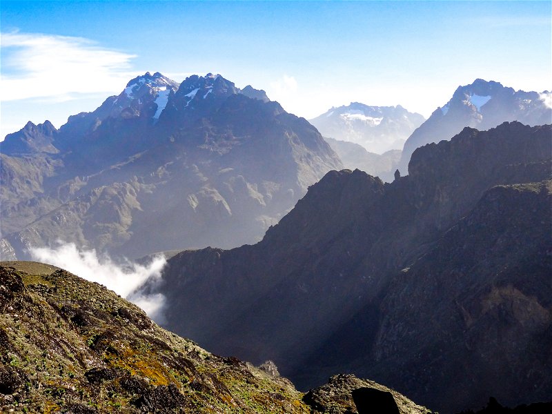
Starting Point: 3,874 metres
End Point: 4,485 metres
Highest Point: 4485 metres
Time Estimate: 4 - 5 hours
Distance: 5.1 km
From Hunwick Camp you will follow the trail down and across the valley floor to Lake Kitandara, a stunning lake with deep water and surrounded by beautiful vegetation. From here you climb up Scott Elliott's pass, then continue your climb up the ridge to Margherita Camp, your base camp to summit the peak tomorrow. The camp is situated between some huge rocks which offers some shelter from the strong winds, whipping over the mountains. You will now truly be following in historic footsteps as this is the very spot where the Duke of Abruzzi camped when making his climb up to Margherita Peak in 1906. You can spend the rest of the day resting at your camp and take an early night as you will be departing very early the following morning to ascend to the summit of Margherita Peak!
Day Seven
Margherita Camp to Hunwick Camp
Starting Point: 4,485 metres
End Point: 3,874 metres
Highest Point: 5,109 metres
Time Estimate: 3 - 4 hours
Distance: 5.1 km
Wake up at 2:00am and catch an early breakfast before beginning your ascent of Mt Stanley at 2:30am. The early start is necessary as the weather has changed a lot in recent years and often even during the dryer season the mountain is closed in with heavy clouds. Snow falls from around 13:00pm to 16:00pm which happens within a short burst of 10 to 15 minutes as the clouds rise up from the extensive Congolese rainforests. Due to this change in weather we have set a strict turnaround time of 10am so if you do not reach the peak before then you must turn around regardless of the disappointment in the interests of safety. Margherita glacier has also suffered with global warming and as the outer edges of the glacier recede the ice is becoming steeper with one section of about 200 meters more than a 60% grade. It is therefore necessary that clients understand and take advice of where the guides suggest to pass. For those clients with less mountaineering experience we suggest that you stay on Stanley glacier and climb up to a good vantage point on a rocky outcrop on the southern edge of Alexandra Peak to enjoy fantastic views over the expansive rainforests of D.R. Congo and the lower mountain ridges. You will then descend back down the mountainside and then follow Scott Elise Pass to return to Hunwick Camp where you’ll be staying overnight.
Congratulations, you have summited ‘The Mountains of the Moon’ at 5,109 metres!
Day Eight
Hunwick Camp to Kiharo Camp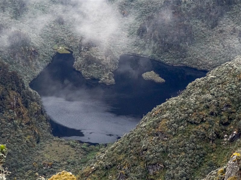
Starting Point: 3,874 metres
End Point: 3340 metres
Highest Point: 4505 metres
Time Estimate: 5 - 7 hours
Distance: 11 km
From Hunwick Camp you will start the day by climbing up the 3km ridge towards Mc Connell’s Prong, from where you get the best views of all three peaks before continuing onto Oliver’s Pass which lies at an altitude of 4,505 metres, a 3 km hike from Hunwick Camp. The trail then cuts across below Weismann’s Peak and continues onto the confluence at the Nyamwamba River, which flows down through Kilembe, Kasese town and onto to Lake George in Queen Elizabeth National Park. If you wish to climb Weismann’s Peak which reaches 4,620 metres from Oliver’s Pass you may do so at an extra cost. From this summit on a clear day you get fantastic views of Margherita Peak on Mt Stanley, Mt Speke and Mt Baker. After crossing the river, the trail meanders down the valley to reach Kiharo Camp. Along the way down the valley you will pass over several bogs after each you will climb over a ridge of stones and earth which were pushed there by slow moving glaciers. When these glaciers melted they left a pile of rocks and debris in front of where the glacier once stood. Tonight you will stay at Kiharo Camp, which lies amongst evergreen plants and babbling streams. Particularly during the dryer months the night the air is filled with the calls of the rock hyrax as they sit in the rocky cliffs high above.
Day Nine
Kiharo Camp to Kilembe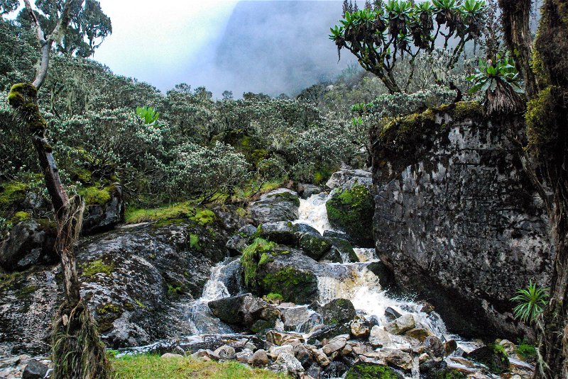
Starting Point: 3430 metres
End Point: 1450 metres
Highest Point: 3430 metres
Time Estimate: 8 hours
Distance: 15 km
Begin your day trekking back down to Kilembe by following the trail along the Nyamwamba Valley, which is mostly downhill. With cascading waterfalls, mossy rocks lining the river, deep valleys and ancient forests creating one of the most stunning vistas in the Rwenzori Mountains. In 1937 the explorer and geologist McConnell tried to find a way up this valley but failed and had to turn back and search for another route through the mountains. After six years of exploring, your hiking guides and porters have found a suitable trail for you to experience this truly beautiful valley. A few kilometres from Kiharo Camp the path starts to follow the river, if you wish then you may prefer to walk down the river itself hopping across the rocks. In the clear areas you may catch a glimpse of a duiker quietly feeding in small clearings. A few kilometres further and the route becomes steeper so you will have to follow the path away from the river course and along a narrow ridge to bypass the steep sections. At the bottom of the path you will rejoin the river where you can rest at the rock shelter for a bit. After crossing a small stream you climb up a gentle slope before turning back down to the river to avoid another set of waterfalls. The forest along this section is magnificent and full of life with many birds, primates, red forest duiker and hyrax to spot as you complete your hike back to the rangers post on the park boundary. Here you will stop off for a quick debriefing with the Uganda Wildlife Authority rangers and continue for another 2.2km to reach Kilembe, the end point for your hike in the ‘Mountains of the Moon’.
Day Ten
Transfer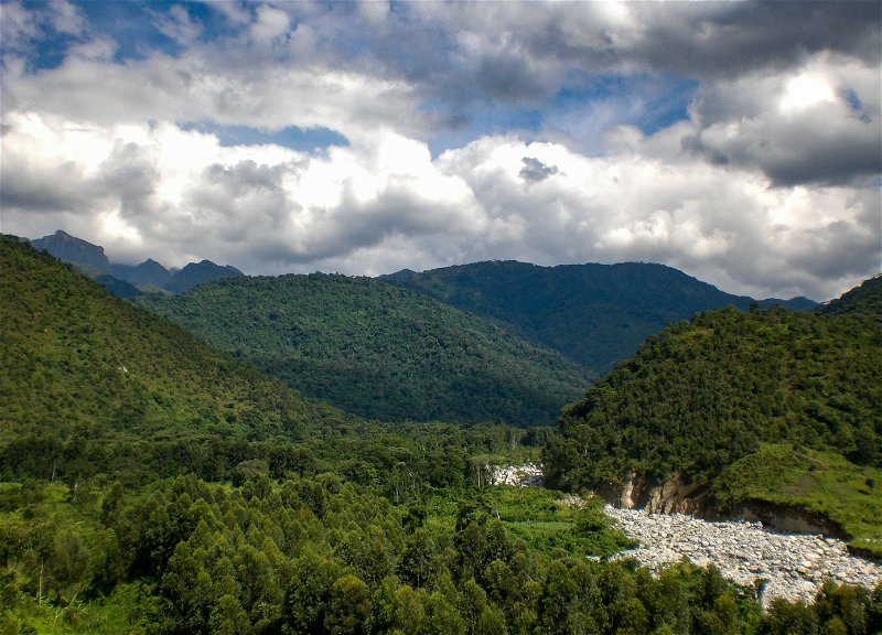
Transfer from Kilembe to Entebbe or Kampala. Estimated journey time: 10 hrs.
[scheduled flight option available]
Share This Page